Portal facilitates access to Amazonian geospatial data
Portal facilitates access to Amazonian geospatial data
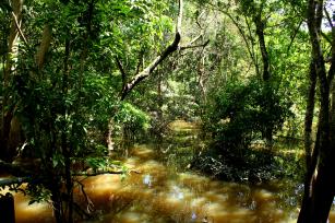
Photo: Embrapa

Free access geospatial data will allow anyone to faster analyze and better understand the dynamics of land use and cover in the Brazilian Amazon region. The GeoPortal TerraClass, a technological solution with free new analysis tools, is already available online for consultation and map analysis in real time.
The virtual platform organizes information from a series of mappings carried out by the TerraClass research project in the deforested areas of the Amazon biome. These are data and maps from the years 1991, 2000, 2004, 2008, 2010, 2012 and 2014, which record all changes in vegetation cover, allowing geographic consultations by region, state, city and Water Planning Units (UPH).
These data were already on the web for public consultation, but in raw format, which required prior work on computational processing and the use of geographic information systems to then carry out specific analyses. With the new technology, researchers have incorporated and made several visualization and analysis tools that generate tables and graphics accessible, facilitating analysis on the computer screen.
“There's no longer a need to download the data, process it and then carry out the studies to understand that changes have occurred in the geospatial dynamics of the region,” says the Embrapa Agricultural Informatics Júlio Esquerdo. “Raw data are still available, but we rearranged it in an updated interface and also created a service that allows query results to be viewed directly on the web,” he explains.
The service, called WebGIS TerraClass, is a Geoinformation system that provides the visualization, overlap and manipulation of the historical series of TerraClass mappings in a fast, interactive and intuitive way. It also offers tools for graphical and numerical comparison between years and features for the analysis and understanding of transitions.
“Moreover, it is possible to generate transition matrices that show the time dynamics between thematic classes of land use and cover in different years, allowing the visualization of the transition areas on the maps,” says Alexandre Coutinho, an Embrapa Agricultural Informatics researcher. Thus, with the technology, it is possible to measure and compare what changes occurred in the land use throughout the mapped period and, additionally, know exactly where in the territory they occurred.
The web system also allows one to verify, for example, what purpose was given to the deforestation areas, based on previously identified thematic classes: forest, secondary vegetation, forestry, pasture, crop, mining, urbanization, and many others. When selecting one of the territorial clippings available, one can get to know, through maps and graphs, what type of plant cover there was, percentage of classes and other uses.
“Now with the GeoPortal TerraClass, it is possible to identify and to analyze land use dynamics in the Amazon, allowing us to quickly understand the main driving factors of the changes in the agricultural sector in Brazil, and the subsequent entry of TerraClass Cerrado data will enable us to identify the major changes in the land use and cover in the most dynamic Brazilian region in terms of agricultural industry,” said Claude Anderson, the coordinator of monitoring program and for the Amazon and other biomes at the National Institute for Space Research (Inpe).
Instant queries
The GeoPortal TerraClass is the result of research developed by Embrapa, in collaboration with the Ministry of the Environment (MMA) and the National Institute of Space Research (Inpe). Prior to the GeoPortal, these analyses used to take a long time because of the calculations that needed to be made with the geoprocessing software, according to João Antunes, another Embrapa Agricultural Informatics researcher. "Now the queries are immediate since everything has already been calculated", he explains. Thus, it is quickly possible to know how much of a deforested area has turned into agriculture or pasture, from one mapping year to another.
This information is useful to estimate greenhouse gas emissions in Brazil, as it allows quantifying and qualifying which deforested areas of the Brazilian Amazon have regenerated, providing information to estimate carbon sequestration in a given region. They also make it possible to know the percentage occupied by agriculture or pasture, year by year, throughout the period of the historical series.
"The user can spatially locate the transitions of use and cover of the area effectively. For example, what used to be forest became pasture, then became agriculture. And the web system shows this trajectory over the years in images, not just through tables. Therefore, it is a fundamental tool for any planning focused on the sustainable development of the region,” says Adriano Venturieri, head of Embrapa Eastern Amazon.
Technology brings important information to support the management of environmental policy, contributing to the elaboration of socioeconomic development public policy. Through the available data, it is possible to know the dynamics of land use and cover in more than 70% of the Brazilian territory – in the Amazon and Cerrado biomes, with spatial resolution of 30 meters.
“GeoPortal TerraClass comes to innovate over other technologies already available, because in addition to enabling the user to download data, it allows the analysis of land use and cover dynamics with a quick and accurate time assessment. These data on the Amazonian environment are important for decision-making and implementation of public policy aimed at optimizing space and reducing the environmental impact of human occupation,” says Alessandra Gomes, Inpe's Amazon Regional Center researcher.
TerraClassThe results generated by TerraClass help define government actions related to the development of sustainable national agricultural production, support actions aimed at preserving national biodiversity, and maintaining the quality of ecosystem services. New maps of the Amazon biome are planned for the years 2016 and 2018. The land use and cover mapping in the deforested areas in the Cerrado bioma was carried out in 2013. The 2016, 2018 and 2020 studies are also established in the research project execution plan and may be integrated into the GeoPortal in the future. |
Photo: iStock
Translation: Emanuelle Galdino, supervised by Mariana Medeiros
Nadir Rodrigues (MTb 26.948/SP)
Embrapa Agricultural Informatics
Press inquiries
informatica-agropecuaria.imprensa@embrapa.br
Phone number: +55 19 3211-5747
Ana Laura Lima
Embrapa Eastern Amazon
Press inquiries
amazonia-oriental.imprensa@embrapa.br
Phone number: +55 91 3204-1200
Further information on the topic
Citizen Attention Service (SAC)
www.embrapa.br/contact-us/sac/